Explore your world, start here.
January 12, 2012
Google has always been on a mission to help organize the world’s information, and our Google Maps and Google Earth teams constantly work to apply this to place and space. A quick retrospective look at 2011 shows a number of improvements to help our users discover and experience new places around the world, both digitally and in person.
To start, we’ve continued to add new satellite and 45 degree imagery on Google Maps and Google Earth, which reached 1B downloads last year, as well as expand our imagery coverage of Street View to Belgium, business interiors, partner locations like parks and even museums with the Art Project. If you want to follow these imagery updates, we expanded Follow Your World so you can get notifications about locations that interest you.
You may have also noticed improvements to the look and feel of our maps, especially with 3D buildings across the world (e.g. Rome, Italy) and smoother transitions with the introduction of Google MapsGL. Using WebGL technology your maps experience is much better with 3D buildings, smoother transitions between imagery and the ability to instantly “swoop” into Street View without a plugin.
 Providing the latest map data has also been an important goal, which is why we introduced Google Map Maker in the U.S. and Canada to reach a total of 188 countries where users have an easier way to contribute local knowledge. Up-to-date maps can also enable other organizations be more effective, such as relief and aid organizations who were able to access imagery after the earthquake and tsunami hit northern Japan, and organizations that use Google Earth Builder to build on top of our APIs.
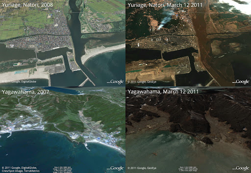
Before and after the earthquake and tsunami.
And of course, your mobile device enables you to take Google Maps with you wherever you go. We recently made indoor maps available with a more accurate blue dot to help you orient yourself, as well as offline maps so you can still see a map area when you’re not connected. The video below shows some of the ways Google Maps can help through all parts of your journey.
To learn more about some Google Maps features, check out our interactive tour at maps.google.com/starthere


 Follow
No comments :
Post a Comment
Note: Only a member of this blog may post a comment.